Serving Beaverton & all of Washington County, OR Free estimates: (458) 272-9359
Beaverton Excavation Co.

Home › Cedar Mill

Site Preparation in Cedar Mill, OR

Cedar Mill Creek drains directly into Beaverton Creek — site work here means the erosion-control plan comes before the grading plan, not after it.

Licensed & insured in Oregon Free on-site estimates Local Washington County crew Wet-season ready

Site preparation in Cedar Mill is more closely watched than it is in most of the unincorporated Washington County communities close to Beaverton, and the reason is physical rather than bureaucratic. Cedar Mill Creek flows through the area, originating in Forest Heights in northwest Multnomah County and draining into Beaverton Creek at Tualatin Hills Nature Park. Sediment that leaves a disturbed site here has a direct path into a live waterway. Beaverton Excavation Co. treats the erosion-control plan as a prerequisite for the grading plan on Cedar Mill properties — not a requirement to satisfy after the grade is set, but a document that shapes how and when grading happens in the first place.

Cedar Mill covers 3.33 square miles entirely north of U.S. Route 26, with a population of 17,259. The community takes its name from a sawmill that operated on Cedar Mill Creek, cutting Western Redcedars that once dominated the area. That creek still runs through the community today, and North Johnson Creek joins it at the Nike World Campus nearby. Cedar Mill Falls is the only waterfall in the area. The creek system means that ground-disturbing work anywhere in this drainage basin carries a direct downstream consequence, and Clean Water Services — which has jurisdiction over erosion and sediment control in Washington County — reviews site work here with the creek in mind rather than treating it as a generic grading project on an isolated lot.

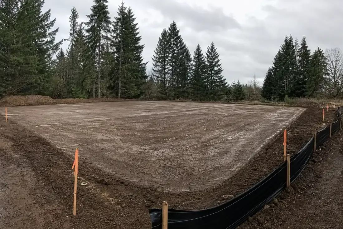
Site preparation work near Cedar Mill Creek with erosion control barriers and silt fencing installed before grading begins
Erosion controls are in place before the first bucket moves on Cedar Mill properties close to the creek drainage.

What Site Preparation Near a Live Creek System Requires

The sequence of steps on a Cedar Mill site preparation project is different from the sequence on a site in an area without a direct stream connection. The standard residential site preparation approach — mobilize, grade, then address sediment management when it comes up — does not work when the downstream receiver is Cedar Mill Creek rather than a parking lot or undeveloped field. Here is how a compliant, functional site preparation project gets structured in this drainage basin.

Every step in this sequence has a reason grounded in how water moves through this drainage area. Treating the creek as background context rather than as a governing constraint on the project produces the outcome Clean Water Services enforcement is designed to address. The excavation contractors in Beaverton, OR who work in Cedar Mill understand that the creek is not an obstacle to work around — it is the condition that determines how the work is structured from the start.

How the Cedar Mill Creek Drainage Affects Soil Conditions and the Working Season

The Tualatin Valley silty clay that underlies most of the unincorporated Washington County communities stays wet for an extended period after the October-through-May wet season ends. Near Cedar Mill Creek, that period is longer. Soils in the creek’s immediate drainage area are recharged from below by the water table as well as from above by rainfall, and the water table in creek-adjacent properties can remain elevated weeks after upland properties have drained sufficiently for compaction work to begin. That difference is not obvious from a surface inspection of the lot. A site that looks workable — no standing water, surface soil firming up — can still have plastic, saturated material starting a foot or two below the surface, which is exactly where structural fill compaction needs to be correct.

What a Shorter Workable Season Means for Project Planning

The practical implication of a creek-adjacent water table is that site preparation work near Cedar Mill Creek starts later in spring than it does on upland properties and must finish earlier in fall to stay ahead of the wet season. Scheduling that does not account for this difference produces one of two problems: compaction work done in soil that will not hold, or a project that runs past the fall weather window and leaves a disturbed site unprotected through the first storms. On a parcel close to the creek, an unprotected disturbed site in November is a sediment-discharge problem, not just an aesthetic one. Our Beaverton excavation team evaluates soil conditions at depth rather than at the surface before scheduling compaction work, and we build the creek-adjusted seasonal window into the project timeline from the start rather than discovering it matters after mobilization.

Clean Water Services Review, Permit Requirements, and What to Expect

Clean Water Services is the service district with jurisdiction over stormwater and erosion control in Washington County, and it reviews site plans for ground-disturbing projects within its service area, which includes Cedar Mill. The Clean Water Services review for a site preparation project near Cedar Mill Creek evaluates the erosion-control measures planned for the site, the drainage design, and whether the project can be completed without sediment leaving the property and reaching the creek system. That review is not a formality — it requires a site plan that shows existing drainage, proposed grading, erosion-control measure types and locations, and the sequence in which controls will be deployed relative to when ground disturbance begins. Projects that attempt to get the review after grading has already started find that Clean Water Services is less accommodating than it would have been during the pre-construction planning phase.

For sites where the total disturbed area approaches or exceeds one acre — which on larger Cedar Mill parcels or combined lots is a real possibility — Oregon DEQ’s 1200-C general stormwater permit adds another layer of compliance. That permit requires a site-specific stormwater pollution prevention plan, designation of a responsible person for site inspections, and inspection documentation maintained throughout construction. The permit must be obtained before ground disturbance begins. The Beaverton excavation crew handles the Clean Water Services coordination and DEQ permit evaluation as part of the pre-construction planning process so that both approvals are in hand before the first machine arrives on site rather than being pursued while a site sits idle waiting for authorization.

Excavation Services We Provide in Cedar Mill

Near a live creek system, sediment management is not an afterthought; find excavation contractors in Beaverton, OR who structure the work around the drainage first.

Drainage & French Drains

Drainage & French Drains →

Site Preparation

Site Preparation →

Utility Trenching

Utility Trenching →

Grading & Leveling

Grading & Leveling →

Frequently Asked Questions

Why is site preparation in Cedar Mill subject to more erosion-control scrutiny than other areas?

Cedar Mill Creek flows through the community and drains directly into Beaverton Creek at Tualatin Hills Nature Park. Sediment that leaves a disturbed Cedar Mill site has a short, direct path into a live stream rather than filtering through a long stretch of upland before reaching water. Clean Water Services reviews site work in this drainage basin with that connection in mind, and the erosion-control requirements reflect the actual downstream consequence of inadequate sediment management rather than a generic standard applied equally to all sites.

Does the DEQ 1200-C stormwater permit apply to residential site preparation in Cedar Mill?

It applies when total disturbed area reaches one acre or more. A single standard residential lot usually does not hit that threshold. But larger parcels, combined adjacent lots, or projects that include driveway and access area grading in addition to the primary pad can reach it. When the 1200-C applies, it requires a stormwater pollution prevention plan, a designated site inspector, and inspection logs maintained throughout construction starting from the day ground disturbance begins. The permit must be obtained before work starts, not after.

How does the water table near Cedar Mill Creek affect site preparation timing?

Properties close to the creek maintain an elevated water table that stays high later into spring than upland sites, because the creek recharges the water table from below as well as rainfall from above. Soil that appears dry at the surface can still be saturated at depth where structural fill compaction is most critical. Attempting to compact wet, plastic clay does not produce the required density, and fill placed into saturated subgrade loses density when the water table rises again the following winter. We assess soil conditions at depth before scheduling compaction rather than relying on surface appearance.

How does the creek drainage shorten the workable season?

The wet season in the Tualatin Valley runs from October through May, but near Cedar Mill Creek the water table stays elevated later into spring than on upland properties. That means the practical start of compaction-quality work near the creek can be several weeks later than on sites farther from stream influence. On the back end, fall work must stop early enough to get disturbed areas stabilized before the first significant storms arrive, because an unprotected disturbed site adjacent to the creek drainage is a sediment-discharge problem within the first storm cycle.

How is site preparation near Cedar Mill Creek priced compared to upland sites?

The creek-adjacent location adds cost through two mechanisms. First, the erosion-control installation required before and during work is more extensive than on an upland site, because the downstream consequence of inadequate controls is a live stream rather than a detention pond or field. Second, the shorter workable season requires more precise scheduling, which can mean mobilizing earlier in the season to ensure the compaction window is not missed. The Clean Water Services review process adds pre-construction time that must be built into the project timeline. We account for these factors in the initial estimate rather than treating them as variables discovered after the project is underway.

What erosion controls are required during site preparation near Cedar Mill Creek?

Clean Water Services specifies controls based on the site area, slope, and proximity to drainage features. Typical requirements include silt fence at the perimeter, straw wattles or fiber rolls at concentrated flow paths, inlet protection at any catch basin on or adjacent to the site, stabilized construction entrance to prevent tracking, and temporary seeding or mulch cover on disturbed areas within specified timeframes. Controls are sized based on the drainage area and expected storm flow, not on what passes a visual inspection on a dry day. On a creek-adjacent site, the standard is whether they hold under winter storm conditions.
Get Your Free Beaverton Excavation Estimate

Send over the basics of the job and we will visit the property, walk the ground with you, and price the scope in writing — no pressure and no obligation. Call, text, or use the form; we reply the same business day.

We only use your info to contact you about your project. No spam, ever.

Prefer to talk?

Call or text to reach our team directly. During business hours we pick up when we can, and every message gets a return call.

(458) 272-9359

Hours: Mon–Sat, 7am–6pm