Home › Cedar Mill
Cedar Mill Creek raises the water table across this community for most of the year, which means any utility trench near the creek corridor requires dewatering, regulated discharge management, and erosion control before a single bucket of dirt moves.
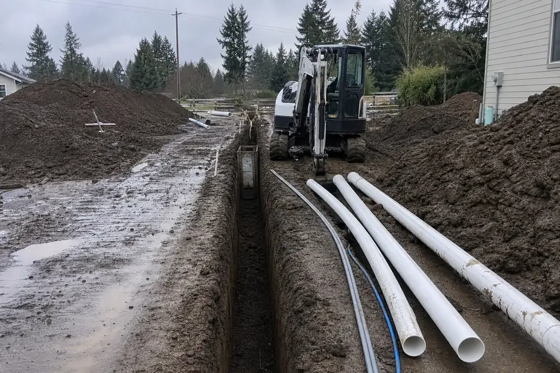
Utility trenching anywhere near a live waterway is a different category of work from trenching across open lawn. Cedar Mill is defined by its creek: Cedar Mill Creek flows through the community, drains into Beaverton Creek at Tualatin Hills Nature Park, and shapes the water table across the surrounding properties for most of the year. When a trench has to run for a new gas service, an electrical conduit, or a water lateral near that corridor, the work becomes a water-management job as much as a digging job. Beaverton Excavation Co. handles utility trenching throughout Cedar Mill with that creek reality at the center of every plan — because ignoring it produces a flooded, unstable trench and a regulated discharge violation.
The silty clay that underlies this part of Washington County does not drain freely. During the October-through-May wet season, the water table near Cedar Mill Creek can sit within two or three feet of the surface in the lower portions of the corridor. Even outside the wet season, soil within a few hundred feet of the creek holds moisture longer than upland areas because the clay fraction retains water rather than passing it through. A trench dug in a dry stretch can encounter groundwater the moment it cuts across a subsurface seam that connects to the creek system. That is why dewatering is treated as standard procedure on creek-adjacent trench jobs in Cedar Mill rather than a contingency.
Six requirements distinguish a trench near Cedar Mill Creek from a standard utility trench, and each one needs to be addressed in sequence before the next can begin safely.
Each step involves coordination between the digging crew, the property owner, and the Clean Water Services erosion-control requirements that govern ground disturbance near Washington County waterways — which is why working with experienced excavation contractors in Beaverton, OR from the planning stage saves time compared to sorting out violations after work has started.
Cedar Mill Creek is not a decorative feature. It is an active hydrological system that North Johnson Creek joins near the Nike World Campus, and its drainage influence extends well beyond its visible banks. The creek raises the local water table across a broad corridor, meaning that properties that look distant from the channel on a map can still experience creek-driven groundwater behavior. That influence is strongest from October through May, when Oregon’s wet season saturates the soil column from the top down while the creek itself keeps the water table elevated from below. The practical result is that even a shallow utility trench — three feet for a gas lateral, four feet for a water service — can hit free-standing water before it reaches design depth. Dewatering is not a sign that something went wrong; it is the expected condition for this ground and this season.
Cedar Mill has been occupied since the 1860s. The JQA Young House, built in 1869 and later used as the community’s post office beginning in 1874, still stands on Cornell Road. Properties with that kind of history have had utility services installed, relocated, and replaced across multiple generations, and almost none of those private service runs appear in any locate database. The 811 locate marks the public mains in the public right-of-way: the water main, the sewer trunk, the gas distribution line. What it does not mark is the private lateral from the main to the meter, the electrical conduit trenched in during a mid-century addition, or the irrigation supply line added by a previous owner. On a creek-adjacent trench job where dewatering is running and the ground is already disturbed, cutting through an unmarked private line mid-excavation creates a complicated repair situation. Our Beaverton excavation crews use careful hand-digging in areas of uncertainty and slow mechanical advance near the structure to find what the locator couldn’t mark.
Clean Water Services administers the watershed protection rules for Washington County, and those rules have teeth near Cedar Mill Creek. Any ground disturbance within the riparian corridor requires erosion controls to be in place before work begins — not installed after the first inspection. The discharge of dewatering water is a separately regulated act: even water that looks clean carries fine clay particles in suspension, and releasing that directly to the creek or to the storm drain system that drains to it violates the permit conditions that govern the job site. The approved method is to direct pumped water to a vegetated area long enough that the velocity drops and the sediment settles before the water continues toward the channel. That area has to be maintained and checked throughout the job, not just set up at the start.
Washington County’s permitting process for utility work in creek-adjacent locations adds pre-construction time, but the permit application itself is manageable when the site plan accurately shows the trench route, the creek setback, the proposed erosion controls, and the dewatering discharge point. Getting that documentation right the first time avoids a revision cycle that costs more time than the original permit would have. The Beaverton excavation crew at Beaverton Excavation Co. has assembled this kind of documentation for creek-adjacent jobs in the Tualatin Valley and can help put together a site plan that satisfies Clean Water Services review without going back for corrections.
From creek-adjacent laterals to service replacements on properties that predate utility records, our team handles the full scope — contact the excavation contractors in Beaverton, OR at Beaverton Excavation Co. to discuss your Cedar Mill project.
Cedar Mill Creek keeps the surrounding water table elevated throughout the year, but especially from October through May. Even in a dry week, the silty clay soil connects your trench to the creek's water table through capillary pressure and subsurface flow paths. Once the trench cuts below the saturated zone, water enters from the bottom and sides regardless of recent rainfall. Dewatering — running a submersible pump continuously — is the standard response on creek-adjacent jobs, not an indication that something went wrong.
No. Storm drains in Washington County discharge to waterways, and Cedar Mill Creek is a regulated waterway under Clean Water Services jurisdiction. Discharging fine-sediment-laden dewatering water into the storm system is a permit violation even if the water looks clear to the eye. The approved practice is routing the discharge to a vegetated area of sufficient length that sediment drops out of suspension before the water reaches any drainage channel. The vegetated buffer has to be maintained for the duration of the dewatering operation.
No. The 811 locate marks public utility infrastructure in the public right-of-way: the distribution main, the transmission line, the sewer trunk. The private lateral from that main to your meter or cleanout is your property and is not in the 811 database. In Cedar Mill, where some properties predate systematic utility records, private laterals can be almost anywhere. We treat every private lateral zone as unmapped territory and use hand-digging and careful mechanical advance near the structure rather than assuming the locate has told us everything.
Plan for roughly double the pre-construction time and 25 to 40 percent more field time depending on the trench length and groundwater level. The pre-construction overhead is permit documentation, erosion-control procurement, and dewatering equipment staging. The field overhead is continuous pump management, sediment barrier maintenance, and backfill with imported controlled material rather than native spoil. A standard lateral that would take a half-day in dry upland conditions may take a full day with dewatering and creek-adjacent erosion controls.
Creek-adjacent trenching carries additional costs for dewatering equipment and operation, Clean Water Services compliant erosion controls, and engineered backfill material when native spoil cannot be reused. On a typical residential utility lateral of 50 to 100 feet, these additions can represent 30 to 60 percent of the base trench cost. Projects that disturb an acre or more also require an Oregon DEQ 1200-C stormwater permit, which adds a permitting fee. We scope each job individually because the creek setback distance and the local water table depth drive the dewatering requirement.
It depends on the setback from the creek and the scope of disturbance. Clean Water Services has vegetated corridor rules that restrict ground disturbance within defined distances of regulated waterways, including Cedar Mill Creek. Work within that corridor typically requires a Service Provider Letter or land-use approval before a county utility permit is issued. For disturbance over one acre, an Oregon DEQ 1200-C stormwater permit is required separately. We can help identify which permits apply to your specific trench route before any work begins.
Send over the basics of the job and we will visit the property, walk the ground with you, and price the scope in writing — no pressure and no obligation. Call, text, or use the form; we reply the same business day.
Call or text to reach our team directly. During business hours we pick up when we can, and every message gets a return call.
(458) 272-9359Hours: Mon–Sat, 7am–6pm